DESCRIPTION
Situated on the Blackwood River, Boyup Brook was named after an Aboriginal word but it is unclear whether that word meant
place of big stones or place of smoke.
Boyup remains a small quiet service centre for the surrounding farms.
The town itself is fairly confusing as it appears to have just grown without any thought of town planning. The streets are
very 'higgldy piggldy' and can be a bit difficult to get a grip on for a first time visitor.
The town is known as the country music capital of W.A. as it hosts the largest festival of its type in the state. The
festival usually takes place on the third weekend in February at the Harvey Dickson Country Music and Rodeo Centre,
just 5km from town.
Boyup Brook Grapevine
This is believed to be the largest grapevine in Australia but as it is on private property, it is not always available
for tourists to look at. The vine is said to have come from Bridgetown in the form of a switch to gee the horses up.
It ended up being planted and has now been growing for over 100 years. It is on a farm about 8km from town and permission
to view it can be obtained via the Visitor Centre.
Dinninup
Nearby in the tiny hamlet of Dinninup was one of the most exceptional collections of teapots you could imagine.
It used to be housed in the home of Robyn and Barlee Jones but sadly Barlee Jones passed away in 2019 and the collection
has now been moved to the Quacking Frog Teapot Shed in Boyup Brook.
Apart from the local caravan park, there are some excellent free campsites in the shire. These include:
Trigwell Bridge (33 40 27.1 S 116 35 55.6)
This campsite is on the boundary of the shire and West Arthur. The bridge spans the Blackwood River and the site has a picnic table.
There is river access to a large pool but swimming is not permitted to due underwater snags.
Eulin Crossing (33 42 04 S 116 40 27.9 E)
This is a particularly nice campsite that also has a picnic table.
There is a launching area suitable for canoes and kayaks and the pool in the river stretches for several kilometres.
Querijup Pool (33 58 01.2 S 116 30 38.9 E)
One of the harder spots to find, this is off Scotts Brook Road and is an open wooded site on a hill sloping down to the brook.
Tone Bridge (34 13 39 S 116 42 15.9 E)
This campsite can be reached from the Boyup Brook Cranbrook Road.
There is a picnic area with a BBQ, toilet and a shelter. Mosquitoes can be bad at this site so take repellant with you if staying overnihgt.
Jayes Bridge
The final campsite is at Jayes Bridge. This is the site of the old Jayes Hall that was built in 1895 and destroyed by a bushfire in 1950. The hall was the first public building in the Upper Blackwood District.
There is a vary large open area with some shade next to the river and a toilet is available.
There are also signs around the site giving information on the local flora and fauna.
Camping and cooking fires banned from 30th October to 1st April at all campsites. Bins are not provided at most sites so please take rubbish away and dispose of it properly.
HISTORY
This area was explored by Augustus Gregory as early as 1845 and was first settled in 1854 by Commander Scott who built a homestead at Scotts Brook south of the town.
Next came James George Lee Steere in 1861, who took up land near the Blackwood River.
In 1871 William Forrest took up land here as well.
The town's development can be traced to the formation of the "Upper Blackwood Progress Committee" by local farmers in 1899.
Their aim was to "advance the interests of this rising and important district".
With an eye to the main game, the Committee proposed the town be named Throssell. The proposal was sent to the Minister for Lands, who was, wait for it, George Throssell - sucky sucky.
Despite the obvious 'brown nosing' the town site was not immediately accepted but the Committee persisted and the town site was gazetted in 1900 - as Boyup.
In 1909 the town became Boyup Brook to avoid confusion with Boyanup.
Early development started with the building of a school in 1900 and then by 1909, the railway to Donnybrook was completed.
Timber mills started up in the area prior to World War Two and some continued to operate until 1982.
A flax mill operated from 1940 to 1965.
Flax material was used to make linen, upholstery and canvas and these materials were in very high demand during the World War Two.
The site where the flax mill once stood is now the site of the town caravan park. Travellers in caravans and motorhomes can collect fresh water at the caravan park free of charge.
Today the area is reliant on sheep, cattle, oats and barley production.
TALL TALES AND TRUE
No information for this section yet. If you know of something we can add here please contact us and let us know.
OTHER INFORMATION
ATTRACTIONS
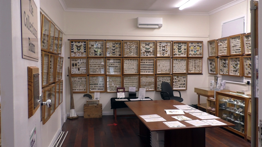
Carnaby's Beetle Collection, Bottle Museum, Grapevine. Art Studio and Aviaries, Bi-Centennial Walkway, Blackwood Crest Winery, Bridge Picnic Area,
Country and Western Music Centre, Glacial Rock Formation, Gregory Tree, Norlup Homestead, Pioneers Museum Scott's Brooks Wines, Storm Boy Jumpers,
Quacking Frog Teapot Shed.
BUILDINGS OF NOTE
Norlup homestead 1874.
Camping sites.
Querijup Pool - Track goes north-east to a quiet crossing on Scotts Brook. Close to Norlup homestead and Scotts Brook vineyard. 33 57 50 S 116 30 45 E
Asplin Siding - Suitable for caravans. Tracks may be wet in winter. 33 48 25.82 S 116 29 23.39 E
Mullidup Pool - Tone River. Suitable for caravans. Could be damp after rain. Large number of sites. 34 07 22 S 116 47 33 E
Tone Bridge - Overnight stop or picnic area.
Trigwell Bridge - Suitable for caravans, close to the road. Overnight stop or picnic. On north side of river and west side of bridge, Flat area -
shelter under the bridge. 33 40 29 S 116 35 50 E
Picnic Sites
Willinarrup - Access track may be difficult. Nice flat area by the river 3km from Boyup Brook.
Sandakan Park - Free electric BBQ, gazebos; small playground area; skateboard park; toilets. Sandakan Memorial to those who lost their lives in Borneo.
Lions Park - Natural bush land setting. Toilet and night lighting. Walk trail around town from here.
Newlgalup - Right hand side of Boyup Brook - Dinninup Road west of Newlgalup Road, 7kms out of Boyup on river side. 33 48 21 S 116 26 43.3 E
Eulin Crossing - Nice flat area by river with boat launch ramp. Large pool 6km long and very wide in some places. Water birds. Very popular spot.
Probably not large enough for camping but excellent for a picnic.
Condinup Reserve - Track off West Arthur Road, 500 metres north of Condinup Road. Track near boundary. Easy to miss. 33 46 20.3 S 116 31 03.6 E
ELECTORAL ZONES
State : Blackwood - Stirling
Federal : O'Connor
OTHER INFO.
Postcode : 6244
Local Government : Shire of Boyup Brook
PHOTOS
Hover over pics in gallery to enlarge.


